- Home Page /
- Sports Outdoor & Fitness /
- Hunting & Fishing /
- Fishing /
- Tools /
- Charts & Maps /
- Curacao Dive Map & Reef Creatures Guide Frank...


Item #:
3986844
Curacao Dive Map & Reef Creatures Guide Franko Maps Laminated Fish Card Map Illustrated, December 30, 2020
Item #:
3986844
NZD 27
Price Details
Excluding Shipping & Custom charges ( Shipping and custom charges will be calculated on checkout )
*All items will import from US
In stock
QTY:
Order now and get it around Friday, June 26
Secured transaction
Ubuy works hard to protect your security and privacy. Our advanced payment security system ensures confidentiality by encrypting your information during transmission using AES (Advanced Encryption Standards) and SSL (Secure Socket Layer) protocols. Your payment details are 100% secure as we do not share your payment details with third party sellers.
Our Top Logistics Partners
Perfect for divers, snorkelers and nature lovers!
Fast
Shipping
Free
Return*
Secure Packaging
100% Original Products
PCI DSS Compliance

ISO 27001 Certified
Note: Step Down Voltage Transformer required for using electronics products of US store (110-120). Recommended power converters Buy Now.


What Stands Out
Laminated Durability
This laminated dive map ensures long-lasting use in wet marine environments, making it perfect for divers and snorkelers. It withstands the elements, providing essential insights without the risk of damage.
Illustrated Guide
The vibrant illustrations of reef creatures offer an engaging way to identify marine life, enhancing the educational experience for divers and snorkelers of all skill levels while exploring Curaçao's underwater wonder.
Comprehensive Coverage
Featuring extensive details of popular dive sites and accompanying fish species, this guide helps users navigate and maximize their underwater exploration. It's the ultimate tool for anyone passionate about marine biodiversity.
Product Details
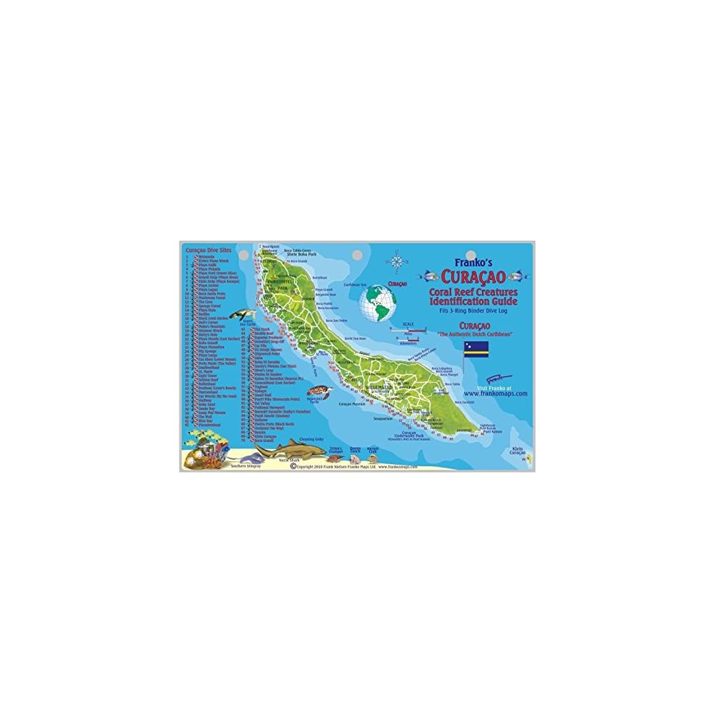
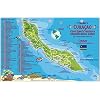
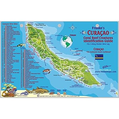
- Perfect for divers, snorkelers and nature lovers! Side One is a mini-map of Curacao with 70 dive sites named and located. Side Two is a fish identification guide with nearly 100 species illustrated. This convenient, waterproof reference is laminated with hole for lanyard. 5.5 x 8.5
| Publisher | Franko Maps Ltd. |
| Publication date | December 30, 2020 |
| Language | English |
| Print length | 2 pages |
| ISBN-10 | 1601901755 |
| ISBN-13 | 978-1601901750 |
| Item Weight | 1.58 ounces (44.79 grams) |
| Dimensions | 8 x 6 x 1 inches (20.3 x 15.2 x 2.5 cm) |
Who Should Buy?

-
Diving Enthusiasts
Ideal for divers looking to explore the underwater ecosystem in Curacao with detailed maps and information.
-
Marine Life Educators
Provides comprehensive insights into reef creatures, making it a great teaching tool for marine biology classes.
-
Travel Planners
Useful for individuals planning a trip to Curacao, helping them navigate popular dive sites and marine features.

-
Beginner Divers
May be overwhelming for novice divers unfamiliar with marine life and specific diving locations.
-
Land-focused Tourists
Not suitable for tourists focused on land-based activities or sightseeing rather than underwater exploration.
-
Casual Beachgoers
Limited use for individuals who prefer relaxing at the beach instead of engaging in diving or snorkeling.
Product Description
Have any Query? Chat with us
Customer Questions & Answers
-
Question:
What does the Cook Islands Dive Map & Reef Creatures Guide include?
Answer: The Cook Islands Dive Map & Reef Creatures Guide features detailed underwater maps highlighting popular dive sites around Cook Islands, as well as information about various reef creatures. This guide is designed for divers and snorkelers, helping them navigate the waters while providing insights on local marine life. It serves as both a practical tool and a learning resource, making it invaluable for planning dives and enhancing the underwater experience. -
Question:
Is the Cook Islands Dive Map laminated?
Answer: Yes, the Cook Islands Dive Map is laminated for durability and protection from the marine environment. This feature ensures that it can withstand exposure to water, sand, and potential wear from repeated use. Whether you're diving or snorkelling, the laminated finish helps keep the map in pristine condition for long-term enjoyment, allowing divers to rely on it during their adventures. -
Question:
Who can benefit from using the Franko Maps Laminated Fish Card?
Answer: The Franko Maps Laminated Fish Card is beneficial for a range of users, including novice divers, snorkeling enthusiasts, marine biology students, and educators. It serves as a quick reference tool for identifying reef species, making it ideal for anyone looking to enhance their underwater experience. Whether used in a classroom setting or during actual dives, this guide enriches understanding of marine ecosystems. -
Question:
Can the Cook Islands Dive Map help me plan my dives?
Answer: Absolutely! The Cook Islands Dive Map provides essential information about dive locations, depths, and terrain, making it easier for divers to plan their dives effectively. It highlights key areas to explore, potential hazards, and underwater attractions. By utilizing this map, divers can optimize their trips and ensure they experience the best of Cook Islands's underwater beauty. -
Question:
Is this guide suitable for beginners?
Answer: Yes, the Cook Islands Dive Map & Reef Creatures Guide is very suitable for beginners. It offers straightforward visual guidance and basic information, making it accessible for those new to diving or snorkeling. With clear illustrations and descriptions, it helps new divers familiarize themselves with the local marine environment, building their confidence as they explore. -
Question:
What types of marine life can I expect to see in Cook Islands?
Answer: Cook Islands is home to a diverse range of marine life, including colorful coral reefs, tropical fish, sea turtles, and various invertebrates. The Franko Maps Laminated Fish Card aids in identifying these species, enhancing your underwater encounters. Knowing what to look for can significantly enrich the diving experience, making you feel more connected with the marine ecosystem. -
Question:
Will the map hold up in wet conditions?
Answer: Yes, the laminated design of the Cook Islands Dive Map ensures it holds up well in wet conditions. This means that whether you're splashing around at the beach or deep underwater, your map will remain intact and legible. It is specifically designed for marine use, allowing you to refer to it without fear of damage from moisture or sand. -
Question:
How should I care for the laminated map and guide?
Answer: To care for your laminated map and guide, simply rinse it with fresh water after use to remove any salt or sand. Store it flat or rolled to maintain its shape and prevent bending. Taking these simple steps will prolong the life of your map and keep it ready for your next diving adventure, ensuring you always have reliable navigation. -
Question:
Is the Cook Islands Dive Map & Reef Creatures Guide portable?
Answer: Yes, the map and guide are designed to be portable. Their lightweight and laminated nature allows for easy folding or rolling, making them simple to carry in dive bags or pockets. This portability ensures you can conveniently access this vital information while enjoying your time in Cook Islands, whether on a dive boat or at the beach. -
Question:
Where can I buy Cook Islands Dive Map & Reef Creatures Guide Franko Maps Laminated Fish Card?
Answer: You can buy the Cook Islands Dive Map & Reef Creatures Guide Franko Maps Laminated Fish Card on Ubuy. This platform offers a wide selection of products, ensuring you can find what you’re looking for, whether it’s for personal use or a gift for an adventurous friend. Ubuy provides access to various items, making your shopping experience streamlined and convenient.
Charts & Maps Editorial Review


The Curacao Dive Map & Reef Creatures Guide by Franko Maps has received positive feedback from customers. One customer praised its sturdiness, vivid colors, and waterproof nature, making it an invaluable tool for snorkeling and diving. They particularly appreciated the fish identification chart and found it useful for their upcoming cruise to the Caribbean. Another customer appreciated the inclusion of dive and snorkel beach sites on the map, as well as the fish identification chart, which they believed would help their kids familiarize themselves with the local fish before their trip. However, some customers found the map to be small, making it difficult to accurately view the numerous dive sites on the island. Additionally, a few customers felt that the map was somewhat basic and generic in nature. Overall, the majority of customers found the Franko Maps Curacao Dive Map & Reef Creatures Guide to be a useful and essential tool for snorkeling and diving experiences. Its laminated, colorful, and easy-to-read design, in addition to the fish and dive site information, received praise from users who found it to be helpful and enjoyable.
Customer Reviews & Ratings
60 customers ratings
-
5 Star
65%
-
4 Star
17%
-
3 Star
10%
-
2 Star
2%
-
1 Star
6%
Review this product
Share your thoughts with other customers
Pros
- Laminated and waterproof
- Vivid colors and clear fish identification
- Inclusion of dive and snorkel beach sites
- Helpful for educational purposes
Cons
- Map can be too small to accurately view dive sites
Product Price History
Important information
- Limitations : For products shipped internationally, please note that any manufacturer warranty may not be valid; manufacturer service options may not be available; product manuals, instructions, and safety warnings may not be in destination country languages; the products (and accompanying materials) may not be designed in accordance with destination country standards, specifications, and labeling requirements; and the products may not conform to destination country voltage and other electrical standards (requiring use of an adapter or converter if appropriate). The recipient is responsible for assuring that the product can be lawfully imported to the destination country. When ordering from Ubuy or its affiliates, the recipient is the importer of record and must comply with all laws and regulations of the destination country.
- Not all the products listed on Ubuy are for sale, as Ubuy is a global search engine. Products are subject to export/trade regulations.
NZD 27
Order now and get it around Friday, June 26
This item is not restrict in my country.(Please click on above link if this item is not restrict in your country, So our team will review and allow.)
QTY:
Secured transaction
Ubuy works hard to protect your security and privacy. Our advanced payment security system ensures confidentiality by encrypting your information during transmission using AES (Advanced Encryption Standards) and SSL (Secure Socket Layer) protocols. Your payment details are 100% secure as we do not share your payment details with third party sellers.
Our Top Logistics Partners
Fastest cross-border delivery
Features & Benefits
- Includes detailed map of 70 dive sites in Curacao
- Features nearly 100 species of fish illustrated
- Convenient and waterproof laminated design
- Ideal for divers, snorkelers, and nature lovers
- Compact size of 5.5 x 8.5 inches
- Great for easy reference and use underwater